LOADING
Mission Ready
Mission Ready
From a 911 call to the final after-action report — every step is automated, tracked, and delivered in real time. No manual dispatching. No waiting.
Autonops connects directly to county and municipal 911 CAD systems via API. The moment a fire incident is dispatched, our system already knows about it.
Caller reports fire
County 911 system logs incident
Mission auto-generated
Total time from 911 dispatch to aircraft launch command: under 90 seconds.
Nine steps from incident to after-action — most happen automatically.
A 911 call or fire report is received and the Autonops system automatically ingests the incident location from the dispatch feed. GPS coordinates and fire classification are captured instantly, triggering the response chain with no manual input required.
The system creates a mission record, plots the fire location on the operations map, identifies the nearest staged aircraft, and calculates an optimal flight path in seconds. A Mission Commander and Controller are auto-assigned based on real-time availability.
An automated FAA approval checklist — developed in partnership with the FAA — confirms airspace, weather, and aircraft conditions in real time. When conditions are met, clearance is confirmed without manual filing, reducing approval time from 20+ minutes to seconds.
The UAV lifts off from its staging location at the local fire station. The Mission Controller monitors liftoff via live telemetry over Starlink from any location in Ohio. Mission status updates automatically to In Progress.
Two simultaneous feeds stream to the Mission Control dashboard and directly to firefighters’ mobile devices: an electro-optical (RGB) feed showing terrain and obstacles, and a thermal imaging feed revealing hotspots and fire lines invisible to standard cameras.
Onboard and cloud AI analyzes both feeds in real time, identifying the active fire line, predicted spread direction based on wind and terrain data, structures in the fire path, and heat signatures from people and animals — generating priority overlays for firefighters.
The remote controller adjusts waypoints, redirects the aircraft, and coordinates with ground crews via live video embedded in the dashboard. All voice communications and decisions are logged automatically for the after-action record.
For supported missions, a Joby air taxi stages at the fire station. A firefighter boards and is transported directly behind the fire line — arriving faster than any ground vehicle, with full situational awareness already streaming from the UAV overhead.
The system auto-generates an AI after-action report, mission score, sortie summaries, cost breakdown, and full communications log — stored to the client account record and available immediately.
Two simultaneous perspectives streaming in real time to Mission Control and firefighters in the field.
Standard RGB camera. Shows terrain, smoke plumes, tree lines, roads, and obstacles. Essential for navigating to the fire and understanding the physical environment.
Infrared thermal camera. Penetrates smoke to reveal exact fire line locations and hotspots. Also detects heat signatures from people and animals invisible to standard cameras.
Autonops UAVs transmit both feeds simultaneously to Mission Control and directly to firefighters' devices in the field.
Real-time tracking of all assets from dispatch to delivery.
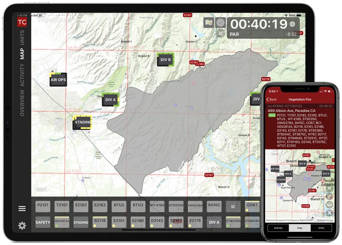
This is what the Mission Controller sees the moment an incident is reported.
Aircraft position, fire location, flight path, and all assets are tracked in real time.
Simulation integration with Sinclair Community College's flight simulator — coming soon.
Nationwide coverage from our Ohio operations center.
Our unique operational model positions aircraft at client locations while pilots operate remotely from our Ohio headquarters. This enables rapid response without requiring on-site personnel.
Aircraft stationed at client fire stations and facilities for immediate deployment when incidents occur.
Starlink connectivity enables reliable remote piloting from Ohio to aircraft anywhere in the country.
Centralized operations enable round-the-clock mission capability without staffing multiple locations.
One pilot can support multiple regions, scaling efficiently as client base grows.
Operations Center
Every AutonOps mission operates under the direction of the Incident Commander. We provide aerial intelligence and situational awareness — the IC makes all tactical decisions.
Safety is not negotiable. Our operational culture is built on discipline, accountability, and continuous improvement.
No mission is worth compromising safety. We maintain strict protocols and never pressure operators to fly in unsafe conditions.
Every mission includes formal risk assessment. We identify hazards early and develop specific mitigation strategies.
We learn from every operation. After-action reviews and lessons learned feed back into our procedures.
View the live mission dashboard or request a capability demonstration.